


I have been calling the carbon capture CO2 pipeline buildout plan a “publicly-funded sewer system for the fossil fuel industry” for some time. In fact it’s their only lifeline, and in the meantime it’s also really good for greenwashing and TV ads.
A reality check is in order. New analysis here of a major report published by Princeton in 2020-21 reveals a “blueprint” for cutting carbon emissions that includes a Trans-Alaska Pipeline sized transmission pipeline running from New Jersey to Georgia and two or three 48 inch diameter pipelines running in tandem, for hundreds of miles, down the Ohio and Mississippi valleys and across the south.
The Princeton mapping exercises have no apparent consideration of people who happen to be in the way. They are aimed at the cheapest solution, the least-cost, shortest distance between two points the pollution source and the dump. The CO2 pipeline buildout is shaping up to be the biggest environmental justice insult ever. Because where will these pipelines be built? Through communities and over people’s land who don’t have the clout to stop them.
An unspoken global dilemma with the pipe dream of Carbon Capture and Storage (CCS) is this: the carbon pollution coming out of smokestacks at power plants, refineries, chemical plants, cement kilns, steel mills, and ethanol plants is often nowhere near the proposed CO2 dumps – deep saline aquifers geologists have scoped out and where people theorize we can put the multi-gigaton CO2 genie back in the bottle.
Meanwhile, the concept of CCS has become a central to “Net Zero” pledges by corporations and governments around the world, including the Biden Administration. The notion has been around for over 50 years, but the legacy, viewed with unbiased goggles, is one of colossal project failures.
NOTE: This article is not detailing the many other problems with CCS – the massive buildout of new chemical facilities on top of old dirty industries in underserved communities, the wasted energy needed to execute the “capture” and compression of CO2, the massive quantities of new chemicals needed, the disposal of millions of gallons of toxic brine that must be pumped to the surface from the saline aquifers to make room for the CO2, to avoid causing earthquakes, and on and on. For more on those problems, see CarbonCaptureFacts and the Center for International Environmental Law for starters.
Here we are talking about a basic practical question: what would it take to build a “sewer system” big enough to handle the carbon dioxide that polluters are currently dumping for free in the atmosphere? What would that pipeline network look like in real life?
Princeton Net Zero America report 2020-21
Shortly after Biden won the Presidency, Princeton University published a 350 slide powerpoint deck and lots of data in a report called Net Zero America, a really ambitious piece of work to back up the Biden campaign pledges around climate change. It looks like an actual “plan” to overhaul our energy infrastructure and help decarbonize our economy, which is the goal.
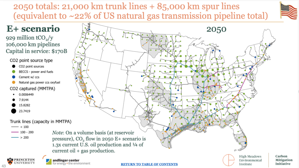
The Net Zero America Report has a whole section on CO2 pipelines because of course you have to tackle this question if you are serious Princeton-level thinker. The Princeton modelers determined that we need system of pipelines totaling up to 68,972 miles (111,000 km) at a cost of $135 billion dollars by 2050. A JPMorgan analyst took a close look at the Princeton figures and concluded that the proposed massive buildout of CO2 pipeline and CCS infrastructure would unfortunately only capture 15% of current US greenhouse gas emissions:

In 2007, Lee Raymond, former ExxonMobil CEO, made a similar cynical point about the scale of effort that would be involved to build out CCS pipelines. Someone at Exxon had done the math 20 years ago. Speaking just about coal fired power plants, Raymond said:
“…if you tried to inject all the supercritical CO2 that came from all the coal-fired power plants you end up moving more liquids than the oil and gas industry moves today, just for CO2. So it is a huge, huge undertaking. And, again, people — this gets into a lot of the infrastructure issues, people just assume that that can happen. You can’t assume that’s going to happen. And the cost is going to be very, very significant.”
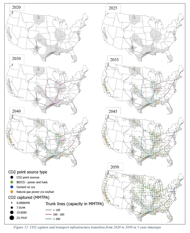
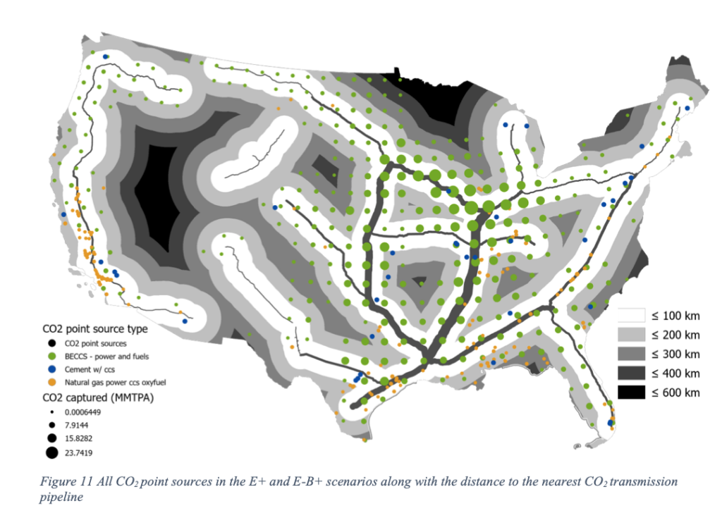
Nonetheless, the optimists at Princeton and CCS advocates in industry, academia and government envision an enormous amount of pipeline being installed in coming decades. Here are the Princeton maps of what needs to be done, downplaying it as smaller than natural gas infrastructure:
A Trans-Alaska Pipeline from New Jersey to Georgia?
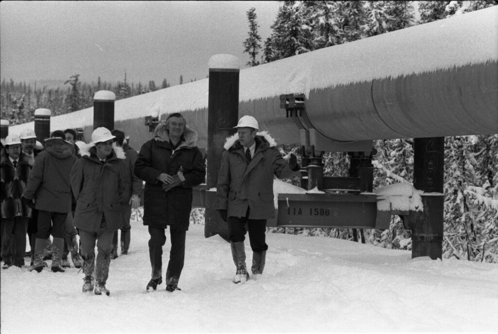
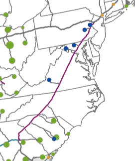
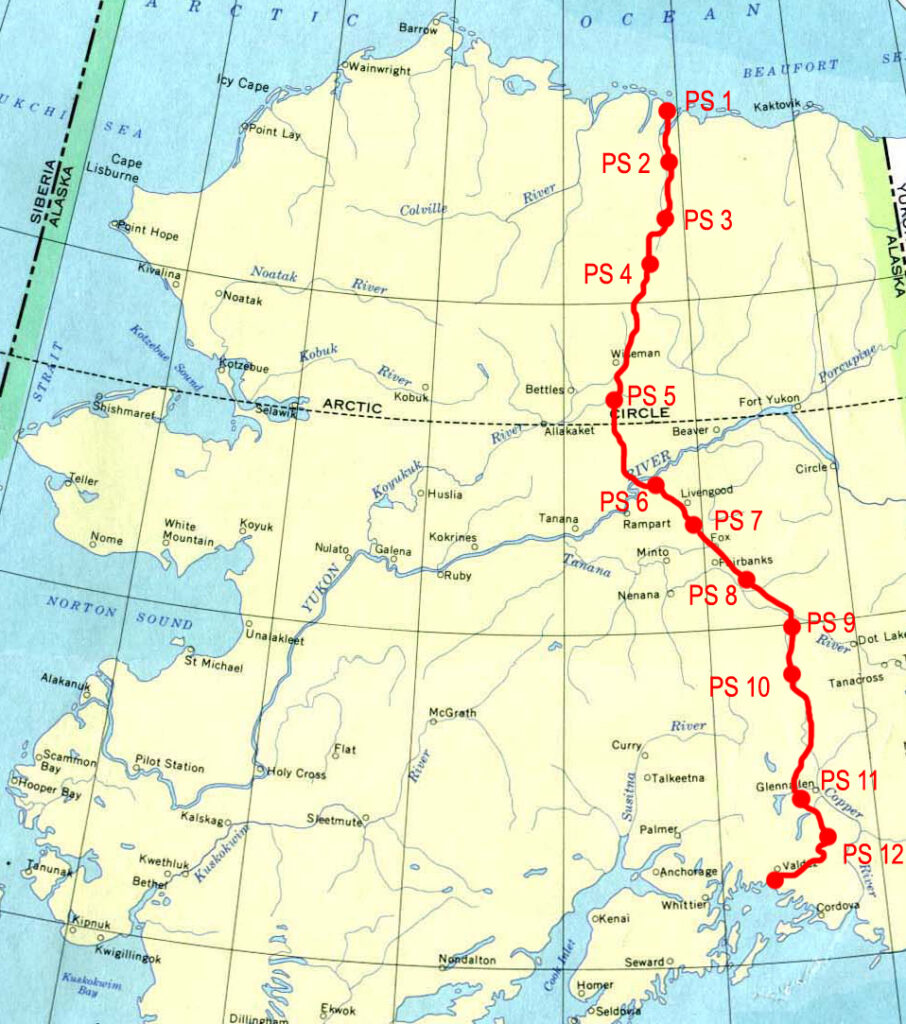
What would this look like on the ground? How about for starters: an 800-mile 48″ pipeline down the East coast from New Jersey to Georgia, almost identical in size and length to the massive Trans-Alaska Pipeline.
Below is the route of that pipeline as proposed by Princeton University modelers in a 2021 report, starting north of Princeton, crossing the Delaware River, skirting the Philadelphia suburbs, sliding north of Baltimore, pretty close to Washington DC, the longest stretch in any state through Virginia, then through western North and South Carolina and into Georgia. Quite an ambitious line to draw on the map. In fact, the Princeton team did draw these lines by hand after mapping out the pollution sources. This “trunk line” pipeline would gather all the New England’s CO2 waste and pick up more from cement plants and other facilities along the way via smaller spur lines.
The price tag for just this stretch of pipeline is estimated to be $7 billion dollars (page 25 of Princeton report Annex). The purple line on the map below is from Princeton report depicts a 48-inch diameter pipeline roughly 800 miles long, from northern New Jersey down to central Georgia. For comparison, the Trans-Alaska Pipeline is 800 miles long and 48 inches in diameter.
Double and Triple 48’s?
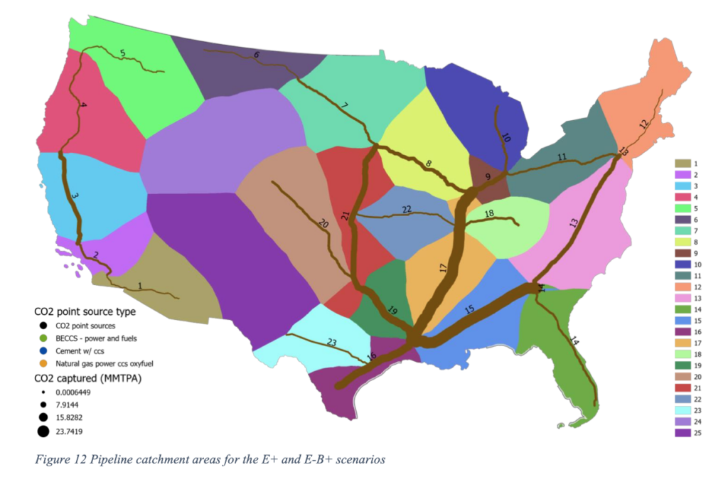
This caught our eye when the Princeton Net Zero America report was published during Biden’s first year in office. Some pipelines on their maps were depicted as massive bars, as in these snazzy diagrams (someone was working late at the Princeton lab). Upon closer inspection of the data, many of these theoretical “Transmission Pipelines” turn out to be two or three tandem 48 inch pipelines, laid side by side for hundreds of miles. The pipeline stretches are numbered on one of the maps and a table in the report list the proposed diameter of that pipe and number of tandem pipelines required, the estimated cost and other stats.
Annex I: CO2 Transport and Storage Infrastructure transition analysis
Annex I: CO2 Transport and Storage Infrastructure transition analysis
In fact, when Princeton scientists did the modeling, adding up the total volume of liquefied supercritical CO2 that would be amassed if these pollution sources were actually “captured,” their computers kicked out fantastical giant transmission pipelines that literally could never exist. So they had to go in and limit the computer to only produce 48-inch pipelines. In many cases this resulted in two or three 48 inchers to carry the volume.

If you look at the technicolor map above, the fat lines get really wide down the center of the country and really start crisscrossing in Louisiana. The scale of the line correlates to volume of CO2 being carried.
Proposed pipeline totals for Gulf states are staggering.
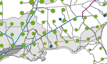
Louisiana
According to the Princeton Net Zero America data report (page 35) the bright blue lines slashing across the map through Louisiana rack up a total of 1,197 miles (1,926 km) of trunk lines, of mostly 48 inch pipe. That’s one and a half Trans-Alaska sized pipelines just in the state of Louisiana! The line drawn down from NE to SW is proposed three pipelines together, let’s call it a Triple 48 – imagine three side-by-side Trans-Alaska Pipelines. The right-of-way would have to be as wide as a highway. On top of the trunk lines, there would be another 1,132 miles (1,822 km) of “spur” lines, gathering carbon dioxide from polluters within Louisiana and from surrounding states. The total for the state is 2,329 miles (3,748 km) of CO2 pipelines to be built by 2040-50.
Mississippi
Stepping east into Mississippi, site of the horrific 2020 Satartia pipeline rupture, the Princeton report shows two trunk line arrays crossing through the state, one in the northwest corner parallel to the Mississippi River and one through the middle of the state east to west. The top one is the Triple 48 that goes into Louisiana. The east-west run picks up the waste CO2 from the 800-mile pipeline and other spurs and is listed as a Double 48 in the Princeton Report. The pipeline totals for Mississippi are 754 miles (1214 km) of trunk lines*, 1,594 miles (2,566 km) of spur lines for a total of 2,349 miles (3,780 km) CO2 pipelines in the state, to be built by 2040-50. That’s nearly a whole Trans-Alaska Pipeline worth of 48 inch pipeline just in Mississippi.
Alabama
Alabama is also laced with CO2 pipelines in the Princeton report. Most of the CO2 waste in these pipes would be from polluters far, far away. The pipeline totals for Alabama come to 416 miles (669 km) of trunk lines, 2,139 miles (3,443 km) of spur lines for a total of 2,556 miles (4,113 km) CO2 pipelines in the state, to be built by 2040-50.
Georgia
Georgia gets three-quarters of a Trans-Alaska Pipeline by virtue of the pipe carrying the carbon dioxide waste from the entire East Coast. Then that is joined by CO2 pipelines from Florida and spur lines north and south that feed into a Double 48 pipeline headed west. The pipeline totals for Georgia come to 563 miles (906 km) of trunk lines, 1,954 miles (3,144 km) of spur lines for a total of 2,517 miles (4,050 km) CO2 pipelines in the state, to be built by 2040-50.
Explore CO2 pipeline plans in other states
- Data for other states is available on this Princeton Net Zero data page. Go to Table 60 in the table of contents which looks like this:

- National
- Alabama
- Arizona
- Arkansas
- California
- Colorado
- Connecticut
- Delaware
- District Of Columbia
- Florida
- Georgia
- Idaho
- Illinois
- Indiana
- Iowa
- Kansas
- Kentucky
- Louisiana
- Maine
- Maryland
- Massachusetts
- Michigan
- Minnesota
- Mississippi
- Missouri
- Montana
- Nebraska
- Nevada
- New Hampshire
- New Jersey
- New Mexico
- New York
- North Carolina
- North Dakota
- Ohio
- Oklahoma
- Oregon
- Pennsylvania
- Rhode Island
- South Carolina
- South Dakota
- Tennessee
- Texas
- Utah
- Vermont
- Virginia
- Washington
- West Virginia
- Wisconsin
- Wyoming
What about Europe?
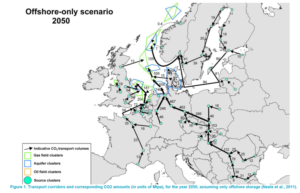
This dilemma is global, not just in the United States. A 2020 report for CCS transportation infrastructure in Europe lays out a plan as if it’s feasible and used this map of possible pipeline routes and dump sites from a published 2011 paper.
Are there other US CO2 pipeline maps?
Good question. The Carbon Capture Coalition has published maps like the one below for years, in various pro-CCS reports, utilizing a Geographic Information Systems (GIS) program called SimCCS. But there are never specifics about the size of the pipelines. The model does estimate cost per mile and seems to trace actual roads, highways, roads, and other rights-of-way.
We at the Climate Investigations Center sued the Biden White House Council on Environmental Quality (CEQ) this year under the Freedom of Information Act to find out how the Administration is using the map below. In the spring of 2021, the CEQ penned a report to Congress that used an abridged version of this map instead of the Princeton maps, without no pipelines depicted in the East or West Coast states for some reason. The CEQ offered no explanation for why this map was chosen. We also sent public records requests to nearly every state and agency that we could think of, asking for any discussion of this infrastructure challenge. Contact us for more information at [email protected].
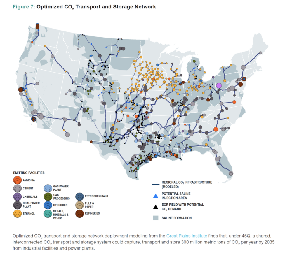
The Department of Energy is still using both the Carbon Capture Coalition maps and the Princeton maps in reports such as the April 2023 Pathways to Commercial Liftoff: Carbon Management that, with a straight face, posits “Different pipeline network configurations have been proposed by various studies, with 30,000 to 96,000 miles of pipeline expected to be required by 2050. (And remember, all this to only catch a small percentage of point source emissions.)
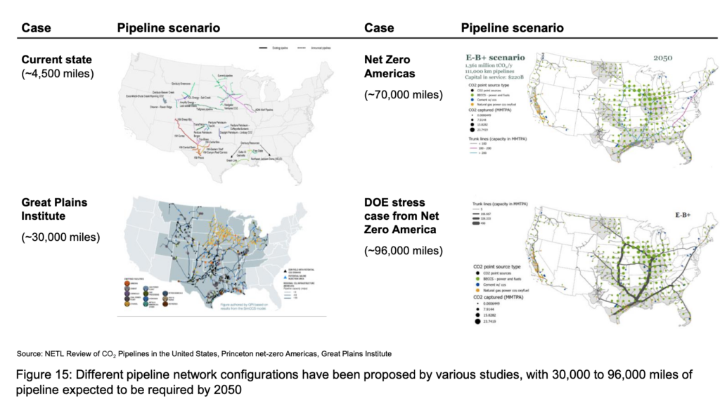
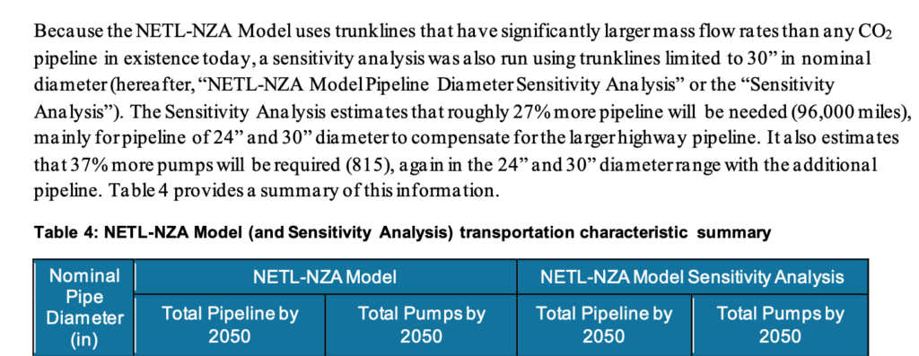
A February 2022 DOE report, called Carbon Capture, Transport, & Storage – Supply Chain Deep Dive Assessment, came up with a scenario that requires 96,000 miles of pipelines. They apparently used Princeton’s data and limited the maximum size of the pipelines to just 30 inches. If you thought Triple 48’s were a problem, it would take about eight 30-inch pipelines to equal the volume of three 48’s.
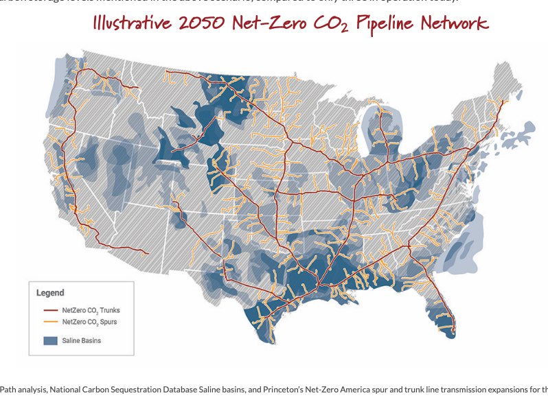
Meanwhile, other advocates keep creating new maps from the Princeton maps. These images have a life of their own.
So what’s next?
The charge of the CCS brigade continues.
- Billions of dollars in grants are on the way out of the Department of Energy, specifically for CCS infrastructure buildout through funding in the Inflation Reduction Act and Bipartisan Infrastructure Bill.
- Three massive projects (Summit, Navigator, and Wolf Midstream) are being railroaded through in the Upper Midwest as local landowners and advocates put up a heroic fight that pits sanity and security against corporate greed.
- The U.S. Department of Transportation’s Pipeline and Hazardous Materials Safety Administration (PHMSA) has proposed that new regulations on these pipelines are needed.
- Over 150 organizations just called for a moratorium on CO2 pipeline construction in the meantime.
Maybe someday the Triple 48 Inch Carbon Sewer will be a tourist attraction down in Louisiana! We doubt it. More likely to be long term liability for people living nearby and a 24/7 worry for first responders who serve to protect them.
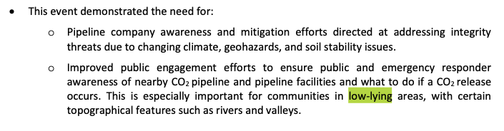
The PHMSA report on Satartia, published one year ago, had this ominous warning to “communities in low-lying areas.” Uh, that would be most of us, especially near probable pipeline routes.

A Trans-Alaska Pipeline tourist trap. Credit: Big Dog 91, CC BY-SA 2.0
But in all seriousness, we were discussing what could possibly go wrong if, say, a mile-wide EF4 tornado with winds up to 190 mph — as just happened in Mississippi and Alabama this March — ran over a Triple 48 Inch CO2 pipeline sitting above ground.
And if you buried it, how deep would you have to go? How would you cross highways, railroads, and rivers? None of these questions appear to have been discussed seriously as of yet.
Kert Davies is the founder and director of Climate Investigations Center. He is a well-known researcher, media spokesperson and climate activist who has been conducting corporate accountability research and campaigns for more than 20 years.